MOONGOBULLA RAAF VERY HIGH FREQUENCY
DIRECTION FINDING (VHF/DF) STATION
NORTH OF TOWNSVILLE, QLD
![]()
The RAAF operated a Very High Frequency Direction Finding Station VHF/DF at Moongobulla about 40 miles north west of Townsville during WWII. Some records show an alternative incorrect spelling of Moongabulla.
D/F Stations rotate a directional antenna until the strongest radio signal is detected and operators determine the location of an enemy or friendly radio transmitter by triangulation using at least one other D/F station. Other RAAF HF/DF stations were located at Julia Creek, Garbutt, Mingela, Brandon and Kairi on the Atherton Tableland.
There is a file in the National Archives of Australia, National Office, titled:-
"DWB (Director of Works and Buildings) - Property - Moongobulla Qld - VHF/DF (Very High Frequency/Direction Finding) Station - Acquisition of site"
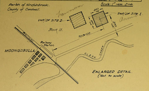
Locality Plan from the above NAA
file showing
proposed VHF/DF sites 1 and 2 at Moongobulla.
Offers were advertised by the Commonwealth Disposals Commission in a number of north Queensland newspapers with a closing date of 5 March 1947 for the purchase of an octagonal shaped building 13 ft x 13 ft. together with fencing posts at the Moongobulla RAAF VHF/DF Station.
Are there any concrete slabs of the site still surviving?
VHF/DF and Radar Sites in Australia during WW2
Military Camps/Locations in Australia during WW2
Bunkers, Tunnels, Fortifications in Australia during WW2
ACKNOWLEDGEMENTS
I'd like to thank Kathy Dawson for her assistance with this web page.
Can anyone help me with more information?
"Australia @ War" WWII Research Products

|
|
© Peter Dunn OAM 2020 |
Please
e-mail me |

This page first produced 30 March 2001
This page last updated 22 February 2020